Sunday, November 29, 2009

Return to Bandera Mountain

November can't keep me from the mountains! I had never hiked on snow before, but yesterday, as part of a very relaxing Thanksgiving weekend, I decided to take on the base of Bandera Mountain. My goal was to reach Mason Lake via the Ira Spring Trail.


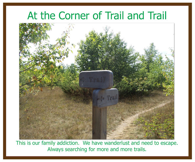
There was a light, soft drizzle for most of my adventure, and after just 45 minutes the trail got even more interesting as I hit snow line. My rain gear held up and my new winter hiking boots handled the terrain expertly. After just a little over an hour on the trail I left the cover of the trees and entered into a clearing that marks the approach to the summit. With the snow much deeper, I quickly put on my brand new gaiters and trudged on. Every tenth step or so I sank in into soft powder, but for the most part the trail was well packed by the snowshoes of previous travelers.


All went smoothly until just a little after 2pm, when it was clear the weather was closing in and my chances of hiking in the dark were rapidly increasing. You see, I only started to hike a little after noon (I slept in way too much), and so I was forced back before things got dangerous. Strangely, six more hikers in two seperate groups were still trying for the summit after me. They almost certainly made their decent after dark. I chatted briefly with one of them, a guy named Xeno, giving what information I could of the trail ahead.

Here are two short videos that I shot shortly after I started back down to the trailhead.


Sunday, October 25, 2009

The BIG Island - - Hawa'ii

A few photos from our trip to Volcano National Park on Hawa'ii. Wil, Krista, Abigail, Ethan, Mike and Lynn, October 2009


the view of Mauna Loa from above the clouds


Abigail is ready to run down the trail!


what a cutie!


Wil running across a lava field


the lava flow across the road

oh, you think?


the steam plume where the lava is hitting the ocean


lava field


we went and saw the lava flow at night....from a 1/2 mile away.
it was hard to take pictures since we didn't have the best camera
for this but these give you an idea anyways


a Ne' Ne'


Wil geo-caching at South Point


We found it!


the LOG


Abigail at South Point


South Point: the southernly most part of the United States (the actual states that is)


entrance to the lighted portion of the Thurston Lava Tube


entrance to the unlighted part of Thurston Lava Tube


inside the Thurston Lava Tube


more inside the Thurston Lava Tube


at the end of the Thurston Lava Tube


Devastation Trail


Abigail getting busy with the camera!


The Steam Vents


view near the "trail of devastation"

Saturday, October 24, 2009

My Recent Invitation

I got a phone call today from a friend of mine named Bruce. He's an avid hiker and vetern of Mt. Rainier (he's made something like 4-5 trips to the summit). He was calling to invite me to join a team and climb Washington's most inconic peak this summer! If all goes well, I'll have a chance to tackle the tallest mountain in the lower 48 this coming July. I have many many pictures of Mt. Rainier, but hopefully I'll get to post some pictures looking down off of it! I'll keep everyone posted, but for now I'm just excited by the possibility.

Also, I climbed Mt. Pilchuck with a friend 1-2 months ago, but never posted any pictures of the trip because I left my camera in the car! I'll post a few of my friend's pictures hopefully soon, once I procure them from him.

Dave

Monday, September 7, 2009

DALMAC 2009

This is a different kind of trail... DALMAC 2009. 328 miles over 5 days. Lansing to the Mackinac Bridge. Great weather! grueling uphills often followed by exhilarating downhills. Mike's max speed 38 mph, mine 33 mph.

Torch Lake


Mike riding up "the wall"


getting ready to ride


my odometer at the end of the trip


Lake Michigan


I don't look victorious, just tired


One of the many groups of kids lining the way cheering on the "DALMACers"


Saturday, August 29, 2009

Bandera Mountain - Part 3

I REALLY REALLY wanted to go hiking today, but the weather is terrible. Weather.com says that there will be scattered thunderstorms right about the time I would have summited whatever peak I chose. Seriously, I'm not really excited about the possibility of getting struck by lighting. This is major setback because I only have a few weekends left to hike before school starts up again. To reach my Summer of Summits goal I'm actually planning on doing two mountains in one day, climbing Silver Peak (5603 ft.), and then Mt. Catherine (5052 ft.) or Tinkham Peak (5295 ft.). This is possible because they are all along the same trail.

But since I'm stuck at home today, I might as well post the final set of photos from my hike up Mt. Bandera. The first five pictures were all taken from the summit of the mountain, and the very last image was taken during my descent. Snow is a feature in images one and two, and I had a fun time sliding on my butt down part of a slope (hiking back up was another matter). There was snow on part of Mt. Si too back in may when I climbed it.

If you haven't already, click on the pictures themselves to see them in their full size, and then go back and do the same with the last two posts. You will be taken back by the beauty of the mountain presented in such detail! Enjoy!


Monday, August 17, 2009

Bandera Mountain - Part 2

Here are some more spectacular images from Bandera Mountain! I've been delayed in posting these due to a busy school schedule (full time work + class = not fun, and no hiking too!!!). Now I'll have some time to tackle a few more peaks, but in the mean time, I'll post parts 2 and 3 of my Bandera Mt. adventure.

The photos below were taken mostly from the beginning of the true Bandera Trail, as it leaves the Ira Spring Trail and climbs a super steep set of switchbacks to the summit. Photos 1 and 3 should give you an idea of just how steep it was. Some (IMHO "crazy") people hiked up the slope just fine, but I opted to use my hands for most of the way. Photo 4 was taken, I believe, near the summit, and it is one of the best pictures of Rainier this trip produced. Photo 5 was taken from the Summit of Bandera Mt., looking at the backside of the mountain. I believe the peak in that photo to be Mt. Defiance, and the pleasant pool below it is called Mason Lake.

In my next entry in this series I will show you some of my best summit photos! The world is absolutely beautiful above 5000 ft!